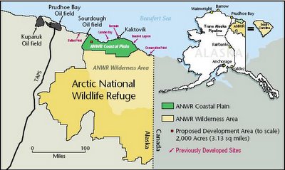
Recently efforts to extract known oil reserves in Alaska's Arctic coastal plain were defeated once again. The coastal plain area of ANWR (Arctic National Wildlife Refuge) is shown in green on the drawing to the right. If you open the image to full size you will see in red the area the Senate wants to open to drilling. The entire Arctic National Wildlife Refuge covers 19.5 million acres. The drawing shows it to be roughly the size of the State of South Carolina. The Coastal Plain (green) covers 1.5 million acres. The barely discernible red square represents the 2,000 acres proposed for drilling. I would like to credit the source of this image, but frankly, I've had it on my hard drive for some time and do not remember were I obtained it.
I've been trying to get this representation of size down to something more conceivable. Luckily, I have AutoCAD and I ain't afraid to use it. AutoCAD is a software application designed for drawing to exact scale. The greatest attribute of the program is that it allows you to draw in full scale, then when you are ready to print your drawing, you specify the size of the sheet being used and the finished drawing is correctly scaled to fit the sheet. In other words, if the device I am designing is to be 20 feet long, I can draw a line 20 feet long on the screen and then zoom in or out to see the entire line.

For example, in this screen capture I drew a football field. In AutoCAD (and in the real world) the distance from endzone to endzone is 300 feet. The dimensions are all perfectly scaled when the drawing will be printed, regardless of the size of the paper I decide to use.
I drew this football field in order to bring the ratios discussed in the first paragraph into a context more relevant to those of us who do not use acres as a daily measurement, not to mention acres in the millions. I assume nearly all of my readers have seen a football field and can conceptualize it's size.
The hashmarks between the full yardlines are each 24" long and 2" wide. Roughly two whole Subway sandwiches laid end to end. Consider the entire field, including both endzones represents Alaska's Coastal Plain that lies within the ANWR (the green part above). All four of the hashmarks between the 45 yard line and the 50 yard line would then represent an area equal to the area of the ANWR coastal plain that is set asiede for drilling. Eight Subway sandwiches lying on a football field represents the small area of the coastal plain proposed for drilling.

Next, I wanted to show the proposed drilling area in relation to the entire 19.5 million acres of ANWR. If you were to download this image you would see a small dot within the zero of the numeral 30 on the opposing team's side of the field. That "dot" does not represent the correct ratio of ANWR to drilling site, assuming the entire field represents all of ANWR. No, that "dot" was something I had to draw there in order for you to see that something was in fact drawn inside the opposing team's 6 foot high "30".

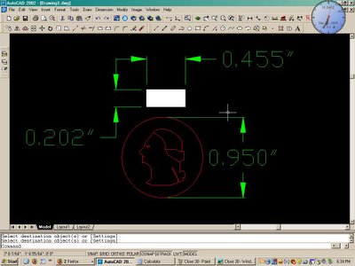
I drew the United States Quarter coin, again in exact scale, that the referee dropped after using it for the game opening coin toss. That Tic Tac just above George Washington's head represents the size of the drilling area in relation to all of ANWR.
If the entire Arctic National Wildlife Refuge were the size of a football field, the area being proposed for drilling would be much smaller than a Tic Tac breath mint. Estimates of the oil reserves that can be extracted from this Tic Tac range between 10 and 20 years at current consumption.
With the power of AutoCAD at my disposal, I could continue and extrapolate a drawing that represents the drilling area in relation to the entire State of Alaska and even to the area of all 50 states combined. But if I did this experiment with just the State of Alaska the resultant drawing would end up being so small as to have no relevance to the real world in the opposite direction.


No comments:
Post a Comment